This is not an exercise that has helped me with settling on a subject for Assignment 3 as I had already decided what I want to explore in that project, and have indeed already started shooting (I got another couple of shots today while out working on this week’s images for Assignment 6). It is though something that is relevant to some of my thinking about post-industrial landscapes and how, over time, such places can revert to something approaching a natural state, and how the knowledge of the industrial past can be lost.
What I am particularly interested in here is the local history of lead mining and smelting. Most of the lead mined in the North East was worked in the North Pennines, in particular in Upper Weardale at places such as Kilhope and Rookhope. Kilhope is of course the home of the national lead mining museum. Unfortunately though, as I have discovered while carrying out my research, it does not appear to be home to an archive resource. There are though a few places in the Tyne Valleywhere lead was mined on a much smaller scale and it is one such site, less than a mile from my house, that I am interested in.
Local lore has it, and I have been aware since moving here more than fourteen years ago, that lead has been mined on the ridge just south of here, probably since Roman times, and carried down the hill to the river, just north of here, whence it was then carried on barges downstream to Newcastle (Pons Aelius). What I have wanted to do with my research is put some flesh on the bare bones.
I must say from the outset that it is clear that this task will require a lot more time than the suggested half day. I have also run into some frustration as although I have been able to identify a number of resources, in particular scholarly articles on the industry in this area, I have not yet been able to gain access to them. We are blessed here with a very fine old scholarly institution in Newcastle, The Northern Institute of Mining and Mechanical Engineers, incorporated in 1876 and housed in an impressive Victorian building in the centre of town (coincidentally next door to the Literary and Philosophical Society of which I have been a member for more than thirty years and visit on a monthly basis). The archives that they hold are extensive and nearly all of the documents that I know exist relating to my local lead mine are housed there. Unfortunately the building is undergoing extensive renovation work which means it will be closed until the autumn this year, and their library is now in storage, and as a result difficult to access. I might be able to get the librarian to retrieve some of the documents that I would like to consult but it is likely to be a time-consuming process.
Subject to that major handicap, I have at least been able to confirm the existence of a mine and smelting site. It is possible that to a large extent the documents still to be consulted will do little more than add further confirmation without necessarily providing much more detailed information. It would seem this was quite a small undertaking and its origins and early life, particularly if it goes back as far as the Romans, will not have been well documented, if at all.
Apart from the local lore (I once met a man who was dowsing, with metal rods, in search of sites related to transport of lead down to the river!) there are clues in local place names. Two in particular are directly relevant. Part of the ridge is known as Bale Hill. At least since Medieval times, a Bale, or Bail, was a smelting site. Here is a diagram of one from the Northern Mining Research Society (to whom I will return below):
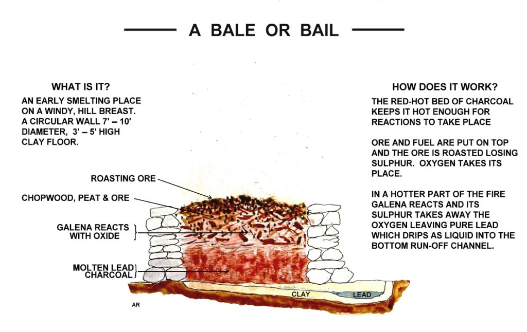
These were used to separate the metallic lead from the ore and were often placed on the upper slopes of hills in order to take advantage of winds and natural air-flow to raise the temperature of the ore. This explains something that had otherwise long puzzled me, why there is more than one Bale Hill within just a few miles of here. There is another one at Healey, a village a couple of miles to the west of here, part of the same ridge, that appears to have been a more important site and one that has been better documented. My Bale Hill is where our local golf course is and no traces remain of the site’s history.
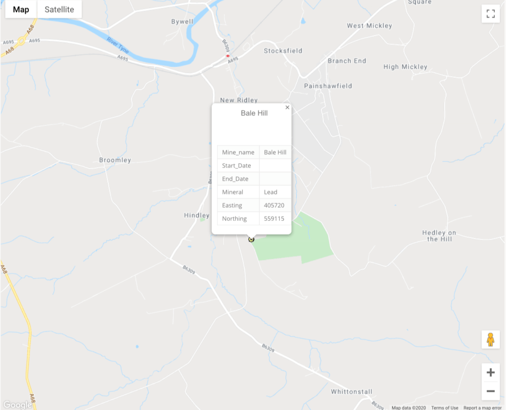
This map is from the NMRS and shows the location of the mine in relation to the river. Her is another in a bit more detail:
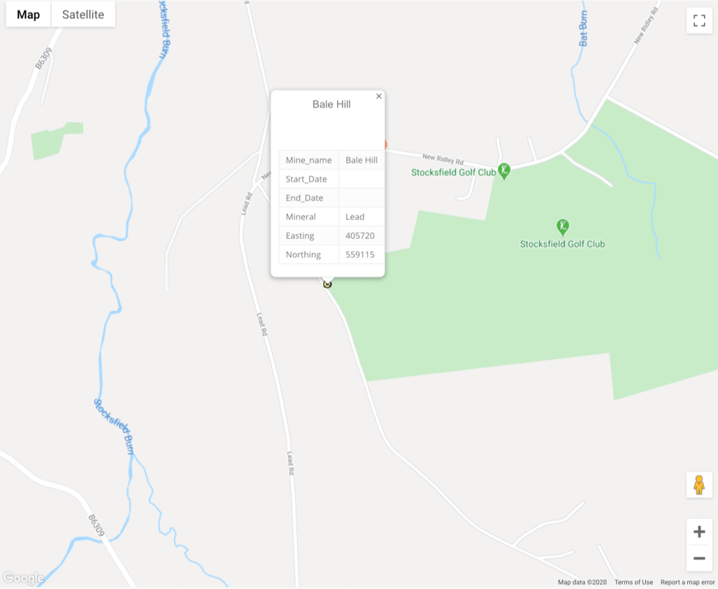
This shows the second geographical hint: the road that runs past the site, and runs down the hill towards the river, is still known as “Lead Road”. In fact, taking a closer look at it an the latest OS map, it can be seen that the road still has this name for much of its length and that it runs along the ridge to the west and links to nearly all the other known lead mining sites in this part of the Tyne valley.
Another snippet of information comes from the environmental search that was carried out when I bought my current house. Unfortunately I do not still have a copy of it (there will though be one in my lawyers’ file relating to the purchase) but I recall it indicated the presence of historical lead working quite close to the house, just below the escarpment on which we are located, in the valley of the Stocksfield Burn that flows north into the Tyne, and next to the lane that links the Lead Road to the river at Bywell. Again there are no physical traces left and it is not clear what exactly might have been done at the site. Local lore though suggests that it might have been a small (one man and his mule!) temporary smelting site.
Although I have not been able to consult any of the NMRS publications at the Mining Institute, I have at least been able to identify a couple of documents that might be relevant. One in particular is issue number 50 of their publication British Mining (at pages 95 to 97) that deals with lead mining, smelting, and iron ore smelting at a number of local sites, including my Bale Hill site. This reference suggests that latterly at least this site might have been used more for iron smelting.
I have also consulted my local library but unfortunately they do not have much on this topic. They do have a copy of another NMRS publication, British Mining 65, Allendale, Tynedale and Derwent Lead Mines by RA Fairbairn but when I checked last Thursday it was not available. However, from the sample pages available on the website (link below) it does not appear that there is much, if anything, in it that relates to my chosen site. At most I expect that these sources will do little more than confirm the existence of the site. The other thing that is apparent from this, and a number of other, otherwise unrelated NMRS publications that I have been able to sample, is that they probably concentrate mostly on the 19th and 20th centuries. What I am more interested in is the much earlier history of the site and I fear that this is not going to be easily available, if at all.
This is not going to form Assignment 3. Nevertheless I have given some thought to how it might be photographed. It is a bit difficult as there are no physical remains and so little information is available to cast any clear light on the activities over time at the site and along the Lead Road down to the river. What might work though would be a series of images simply of the countryside and the route down into the valley as it appears and exists now, if only to show how this post-industrial landscape has not exactly reverted to a previous natural state but has changed with other non-industrial usage.
https://mininginstitute.org.uk
http://www.nmrs.org.uk/wp-content/uploads/2016/09/bm65lookinside.pdf

One thought on “Exercise 3.5: Local History”